


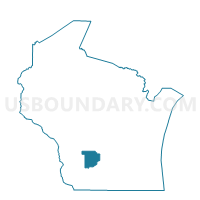
FREEDOM - T 1 Voting District, Sauk County, Wisconsin
About
Outline

Summary
| Unique Area Identifier | 696938 |
| Name | FREEDOM - T 1 Voting District |
| County | Sauk County |
| State | Wisconsin |
| Area (square miles) | 34.71 |
| Land Area (square miles) | 34.30 |
| Water Area (square miles) | 0.41 |
| % of Land Area | 98.83 |
| % of Water Area | 1.17 |
| Latitude of the Internal Point | 43.41504790 |
| Longtitude of the Internal Point | -89.90049520 |
Maps


Graphs
Select a template below for downloading or customizing gragh for FREEDOM - T 1 Voting District, Sauk County, Wisconsin


Neighbors
Neighoring Voting District (by Name) Neighboring Voting District on the Map
- BARABOO - T 1 Voting District, Sauk County, WI
- BARABOO - T 4 Voting District, Sauk County, WI
- EXCELSIOR - T 1 Voting District, Sauk County, WI
- EXCELSIOR - T 2 Voting District, Sauk County, WI
- HONEY CREEK - T 1 Voting District, Sauk County, WI
- North Freedom - V 1 Voting District, Sauk County, WI
- REEDSBURG - T 3 Voting District, Sauk County, WI
- SUMPTER - T 1 Voting District, Sauk County, WI
- WESTFIELD - T 2 Voting District, Sauk County, WI
Top 10 Neighboring County Subdivision (by Population) Neighboring County Subdivision on the Map
- Baraboo town, Sauk County, WI (1,672)
- Excelsior town, Sauk County, WI (1,575)
- Reedsburg town, Sauk County, WI (1,293)
- Sumpter town, Sauk County, WI (1,191)
- Honey Creek town, Sauk County, WI (733)
- North Freedom village, Sauk County, WI (701)
- Westfield town, Sauk County, WI (571)
- Freedom town, Sauk County, WI (447)
Top 10 Neighboring Place (by Population) Neighboring Place on the Map
Top 10 Neighboring Unified School District (by Population) Neighboring Unified School District on the Map
- Baraboo School District, WI (20,079)
- Reedsburg School District, WI (16,838)
- Sauk Prairie School District, WI (15,656)
Top 10 Neighboring State Legislative District Lower Chamber (by Population) Neighboring State Legislative District Lower Chamber on the Map
- Assembly District 50, WI (59,182)
- Assembly District 42, WI (57,978)
- Assembly District 51, WI (57,687)
Top 10 Neighboring State Legislative District Upper Chamber (by Population) Neighboring State Legislative District Upper Chamber on the Map
Top 10 Neighboring 111th Congressional District (by Population) Neighboring 111th Congressional District on the Map
Top 10 Neighboring Census Tract (by Population) Neighboring Census Tract on the Map
- Census Tract 3, Sauk County, WI (6,785)
- Census Tract 6, Sauk County, WI (6,578)
- Census Tract 2, Sauk County, WI (4,901)
- Census Tract 11, Sauk County, WI (4,134)
- Census Tract 5, Sauk County, WI (3,338)